Forest of Avon
6.2 LCT B: River Flood Plain
The map below shows the location of LCAs with LCT B: River Flood Plain. - View map full screen
For help on how to use this map click here.
Landscape Character Type description
The LCT is comprised of two low-lying areas of floodplain associated with the Land Yeo and Kenn River in the north-east of the district, and the Lox Yeo River in the south. These lowland river floodplains have a low and flat topography, contrasting with the rolling slopes and ridges of the adjacent LCTs.
Within North Somerset, LCT B comprises LCA B1: Land Yeo, Kenn River and River Avon Floodplain, and LCA B2: Lox Yeo River Floodplain, as described in the North Somerset LCA (2018)Â and shown on the mapping provided.
Existing tree and woodland coverage
Woodland cover is relatively low across the River Floodplain LCT, comprising 4.4% of land cover. Coverage is higher in LCA B1: Land Yeo, Kenn River and River Avon Floodplain, occurring in small blocks of broad-leaved semi-natural woodland (including ancient woodland), linear woodlands along railway embankments, notably around Cambridge Batch, riparian vegetation following watercourses, and hedgerow trees. LCA B2 Lox Yeo River Floodplain is sparsely wooded, with less than 1% woodland cover. Trees outside woodland make up the majority of tree canopy cover in LCA B2, predominantly as riparian vegetation along the river corridor. Occasional hedgerow trees of willow, oak and ash within low-flailed hedgerow boundaries further contribute to the tree cover within the River Floodplain LCT.
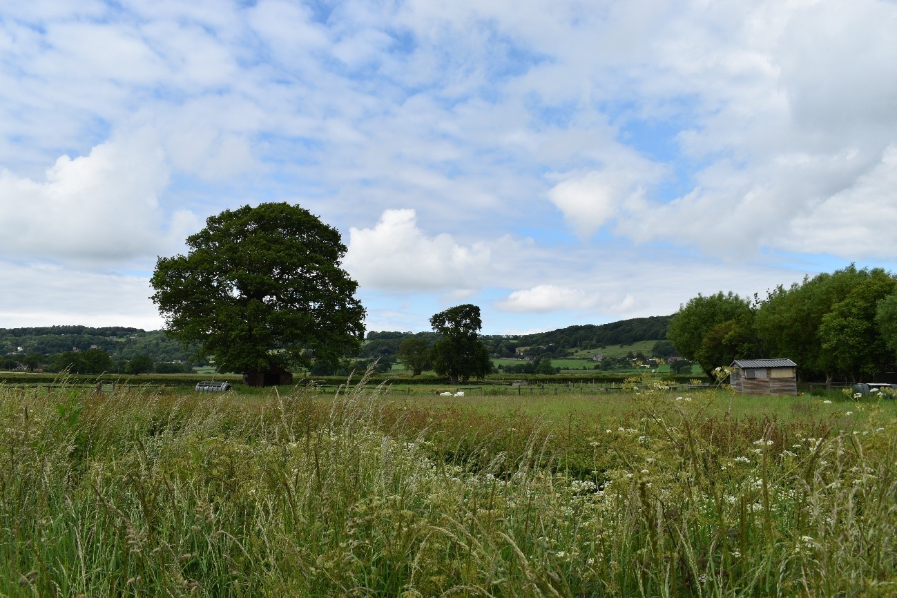
Open views over lowland floodplain pasture in LCA B1.
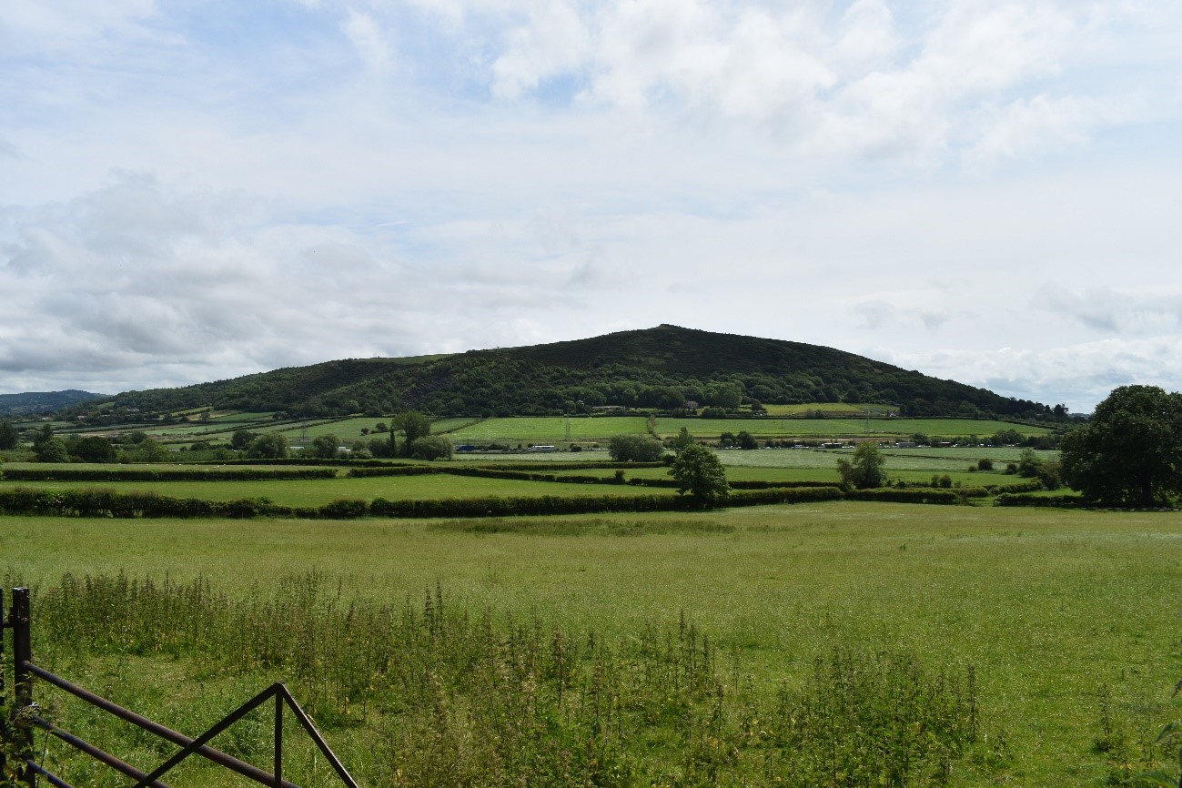
View across the Lox Yeo River floodplain (LCA B2) towards Crook Peak within the Mendip Hills National Landscape.
Land cover composition of LCT B
There was an issue displaying the chart. Please edit the chart in the admin area for more details.View and export full results.
Landscape sensitivities
Landform (including scale and pattern)
- A low-lying, open floodplain with little topographical variation, contained by the rising valley sides of adjacent LCTs. The simple landform indicates lower sensitivity to new woodland planting.
- LCA B1: Land Yeo, Kenn River and River Avon Flood Plain contains more topographical variation, with some gently sloping valley sides in the south around the River Kenn, and to the south of Long Ashton. New small-scale woodland planting could complement the existing contours of the landscape, following the natural vegetation pattern.
Field and landcover pattern
- Medium-large scale rectilinear fields cover much of the LCT, with predominantly pastoral fields enclosed by low hedgerows, with occasional hedgerow trees.
- Landcover pattern is strongly influenced by the rivers and streams and their associated riparian vegetation and wetland habitats (some locally designated). The LCT is vulnerable to new woodland planting that could result in the loss or damage of these habitats, particularly in LCA B2: Lox Yeo River floodplain, which contains extensive areas of floodplain grazing marsh habitat.
- Tree cover is relatively low overall, however small woodland copses in LCA B1 include ancient woodland and are local wildlife sites. There are opportunities for new planting to strengthen and enhance this pattern of woodland cover.
- Rail and road corridors (including the M5 motorway) often lined by vegetation cut through the landscape (particularly in LCA B1) fragmenting the landscape pattern. This lowers sensitivity to new woodland.
Historic landscape character
- Remaining areas of medieval field patterns would be sensitive to new woodland planting which could mask these features as an important component of the historic landscape character.
- The presence of occasional heritage assets including a Victorian bathing pond and estate cottages indicate higher sensitivity to new planting that could cause damage to historic features or impact their setting.
- Historic settlements designated as Conservation Areas (including Christon, Loxton and Yanley) are sensitive to new woodland planting that could impact their setting and integrity, including views to and from the settlements.
Visual character (including skylines)
- Strong sense of openness across the floodplain landscape, particularly within LCA B2 with sweeping views across the valley floor, towards the Mendip Hills National Landscape, and up to surrounding wooded valley sides. This open visual character is sensitive to change from woodland planting which could mask views within the LCT.
- LCA B1 has a strong visual relationship with the parkland at Tyntesfield Estate (LCA E5: Tickenham Ridges and Combes). New woodland planting could screen views towards the parkland if not sensitively designed and sited.
- Modern development on the urban edge of Bristol in the north east and transportation corridors are visually intrusive. New woodland planting could help to integrate these features into the landscape and enhance the visual character of the LCT.
Perceptual and scenic qualities
- A peaceful and rural landscape with tree-lined streams, grazing livestock, and stone farm buildings. This quality is particularly strong in LCA B2, which falls entirely within the Mendip Hills National Landscape. Special qualities include the dark skies, tranquillity, sense of remoteness, and naturalness of the area, as well as views towards the Mendip Hills ridgeline, which would be particularly sensitive to new woodland planting.
- Transport corridors, and incremental changes associated with modern development detract from the perception of rural character. Woodland could help mask these detracting features.
Assessment of landscape sensitivity to tree and woodland planting
Summary
Overall, sensitivity to small-scale woodland creation would be low. This size of woodland could enhance the existing vegetation framework of linear vegetation along watercourses, transportation infrastructure and field boundaries. It could also extend existing small woodland blocks and copses, protecting and buffering ancient woodland. This would increase habitat connectivity as well as screening detracting features, to strengthen the rural character and perceived tranquillity of the landscape. Parts of LCA B1 are adjacent to LCAs with higher woodland cover (e.g. LCA E6: Cleeve Ridges and Combes, and LCA J4: Colliter’s Brook Rolling Valley Farmland) and small-scale woodland planting could be accommodated along these edges to enhance connectivity across the landscape. New woodland planting of this size should avoid masking the highly distinctive open character of the floodplain landscape, particularly in LCA B2.
There would be higher sensitivity to medium sized woodland planting across the LCT. There is currently no woodland of this size within the LCT, and new planting of this scale would mask the existing open character and distinctive pattern of pastoral fields on the floodplain. There may be some limited potential to integrate new linear medium size woodlands, following existing features and contours across the landscape, such as rivers or transport corridors that are already partially vegetated. This would significantly increase habitat connectivity across the LCT.
The LCT does not currently contain any large woodlands, and would be highly sensitive to new planting of this size which would overwhelm and contrast with the existing character of the LCT, masking historic field patterns, and enclosing the open character of the floodplain landscape.
There are currently no commercial conifer plantations within this LCT. The introduction of this type and size of woodland would be discordant with the existing landscape character.
Any variations in landscape sensitivity
Sensitivity to woodland creation larger than small-medium size (5-15 ha) is higher in LCA B2 due to the existing landcover pattern of open pastoral fields, important semi-natural wetland habitats, remnant historic field patterns, and distinctively open character arising from the limited extent of existing woodland cover. The location of LCA B2 within the Mendip Hills National Landscape also increases sensitivity to new woodland planting which could impact the special qualities of the designated landscape, particularly the views towards the Mendip Hills and the distinctive ridge line.
Table A.1: Assessment of landscape sensitivity to tree and woodland planting: assessment scores
| Criteria | Small size native woodlands and trees outside woodlands (≤5ha) | Small-medium size native woodlands (>5 to 15ha) | Medium size native or mixed woodlands (>15 to 30ha) | Large size native or mixed woodlands (>30ha) | Medium-large size conifer plantation (>15ha) |
| Landform (including scale and pattern) | Low | Moderate-High | High | High | High |
| Field and landcover pattern | Low | Moderate-High | High | High | High |
| Historic landscape character | Low-Moderate | Low-Moderate | Moderate-High | High | High |
| Visual character (including skylines) | Low | Moderate-High | High | High | High |
| Perceptual and scenic qualities | Low | Moderate | Moderate-High | High | High |
| Overall score | Low | Moderate-High | High | High | High |