Forest of Avon
6.6 LCT F: Sandstone Uplands
The map below shows the location of LCAs with LCT F: Sandstone Uplands - View map full screen
For help on how to use this map click here.
Landscape Character Type description
An elevated, rolling landscape located in the north of the district. The landform rises steeply from lowland areas in the north and west, meeting the adjacent Failand Settled Limestone Plateau (LCA G2) to the south.
Within North Somerset, LCT F comprises LCA F1: Abbots Leigh Sandstone Uplands, as described in the North Somerset LCA (2018)Â and shown on the mapping provided.
Existing tree and woodland coverage
The Sandstone Uplands LCT comprises large areas of woodland, accounting for 21.7% of the total landcover which is relatively high for North Somerset. This includes deciduous, mixed and conifer plantations. Ancient woodland makes up almost 10% of woodland within this LCT, the second highest area of ancient woodland coverage in the district. Woodland typically occurs on sloping ground of valley sides and along watercourses such as the Markham Brook. Woodland often completely or partially covers the ridge tops, masking the underlying landform and enclosing long-distance views. Woodland is dense and well-connected in the west of the LCT, with smaller isolated blocks to the east. The majority of woodlands are Local Nature Reserves (LNRs). Areas of parkland in the east, and tall, full hedgerows and hedgerow trees along field boundaries further contribute to the well-wooded character of the landscape.
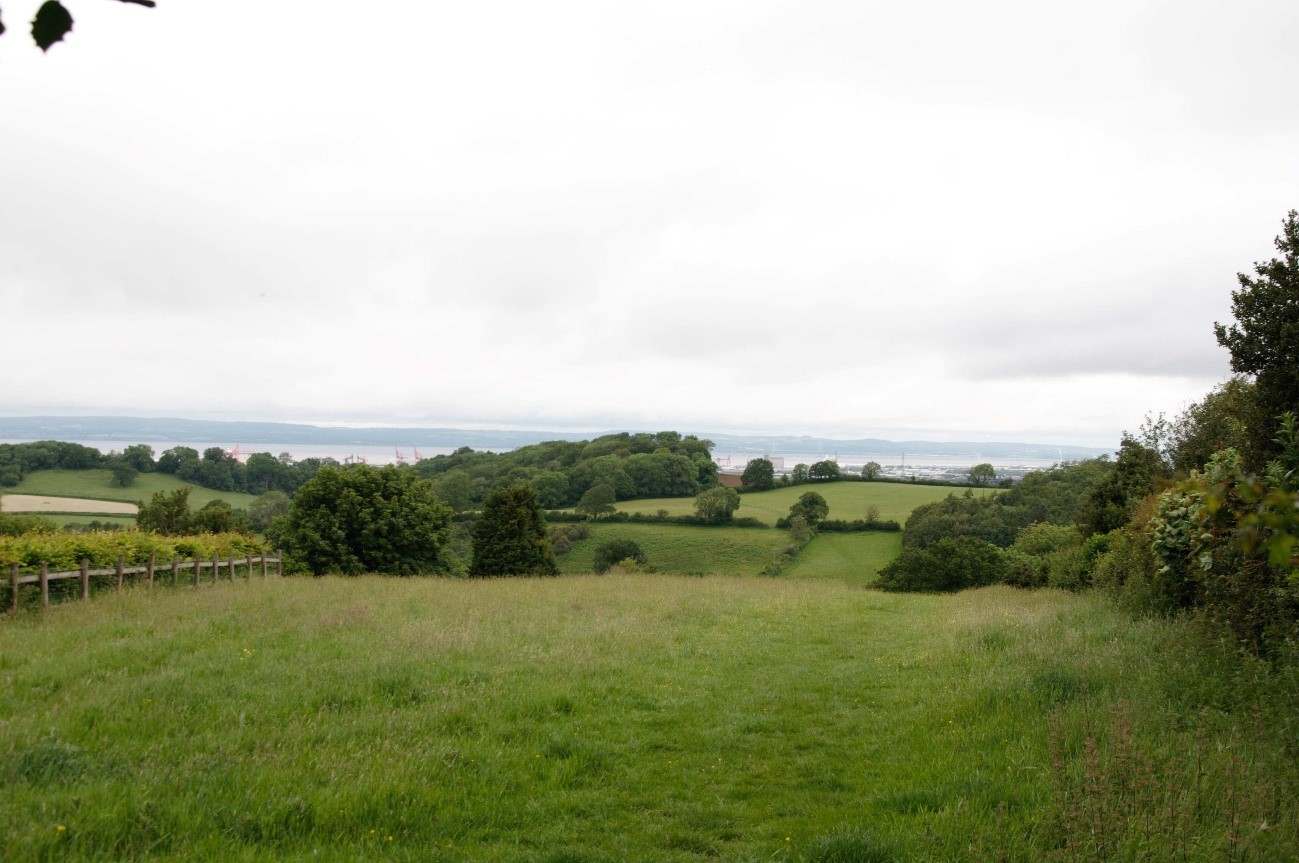
Mixed landcover pattern of small-scale fields with wooded hedgerows and woodland copses, with views to the Severn Estuary.
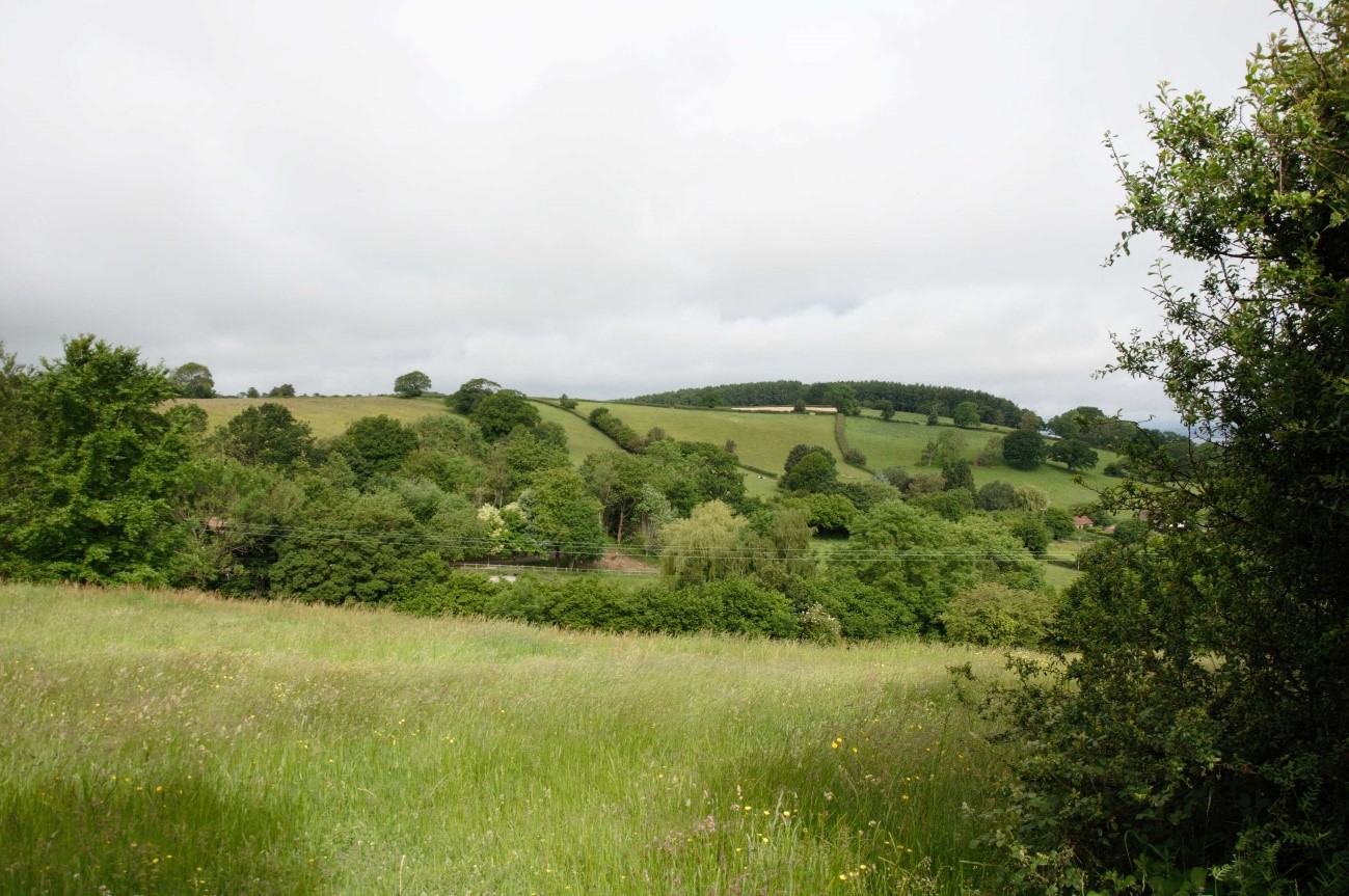
Rolling landform, with woodland following the course of the Markham Brook.
Land cover composition of LCT F
There was an issue displaying the chart. Please edit the chart in the admin area for more details.View and export full results.
Landscape sensitivities
Landform (including scale and pattern)
- An elevated landform of rolling hills and narrow valleys which forms a rural backdrop to lowland landscapes to the north.
- The complex landform incised by small streams and brooks would be sensitive to new large-scale woodland that could mask these distinctive features. However, new small-scale planting could enhance the contours and accentuate the pattern of stream valleys.
Field and landcover pattern
- The intricate pattern of irregular, small and medium size pasture fields bound by full hedgerows would have higher sensitivity to medium-large woodland planting which would mask these landcover patterns.
- Existing areas of semi-natural grassland habitats would have high sensitivity to woodland planting which could result in a reduction of habitat diversity and landscape structure.
- Existing woodlands form an integral part of the landcover pattern of this landscape contributing to its well-wooded character. New woodland planting could be used to strengthen landscape structure and extend and link existing woodland habitats, including ancient woodland.
Historic landscape character
- Historic landscape features including remnant medieval field patterns and large areas of historic parkland associated with Leigh Court (RPG) in the east of the LCT would be sensitive to medium and large sized woodland planting which could mask or dilute the historic landscape character.
- Relic traditional orchards (including a substantial area to the south of Abbots Leigh) evoke a sense of time depth in the landscape. New planting could present an opportunity to enhance and expand this traditional landscape feature to other areas of the LCT.
- Conygar Hill Prehistoric hillfort (a Scheduled Monument) would be sensitive to new woodland planting that could diminish its visual prominence within the landscape.
Visual character (including skylines)
- The semi-enclosed character resulting from the undulating landform, large areas of woodland on valley slopes, and mature hedgerows which screen long-distance views across the agricultural landscape would be less sensitive to woodland expansion.
- In more open areas, views to landmark features such as church towers/spires (such as those at Lower Failand and Abbots Leigh), and dramatic long-reaching views to the Severn Estuary and South Wales would be sensitive change from new woodland planting which could enclose these views.
- The combination of sandstone buildings with surrounding coniferous vegetation makes a striking contrast in village centres and is noted as a key characteristic of the LCA. Any new planting should avoid masking this combination of features as a distinctive element of the LCT.
Perceptual and scenic qualities
- A rural, historic landscape with a pleasing combination of features including small-scale settlement, strong woodland cover and enclosed fields, linked by a network of winding country lanes. Existing tree and woodland cover contributes to the perception of tranquillity in the landscape.
- New woodland planting could provide additional screening or buffering of views to detractive features including the M5 corridor and nearby urban areas and industrial areas (including Portishead, Bristol and Avonmouth docks) which are visible from the north of the LCA.
Assessment of landscape sensitivity to tree and woodland planting
Summary
There would be low sensitivity to small and small-medium sized woodland creation across the LCT. New woodland planting of this scale could extend the strong framework of vegetation (including the tall, full hedgerows and hedgerow trees, woodland blocks of various sizes, and scattered, mature trees within pasture fields) to reinforce the well-wooded character of the landscape. Small to small-medium woodland planting could extend and link existing woodlands within the LCT, enhancing habitat connectivity whilst preserving the diverse landcover pattern and semi-enclosed character.
New medium-sized woodland could generally be accommodated across the LCT. This scale of woodland planting could enhance the rural character of the area and increase the perceived tranquillity by screening/buffering detracting features such as the M5 corridor and industrial/urban areas to the north and east. Connectivity of the wider woodland network across this LCT could be increased with medium-sized areas of new woodland connecting woodland along Portbury Lane in the south-west and gaps south of Lower Failand. Strategically located new medium woodlands could contribute to the creation of a continuous woodland corridor linking ancient woodland in Leigh Woods (LCA D1) to ancient woodland sites in this LCT, as outlined in the Forest of Avon Plan Tree and Woodland Strategy.
This LCT contains several large woodlands, the largest of which is Prior’s Wood (62 ha). Neighbouring landscapes to the south (LCT G2: Failand Settled Limestone Plateau) contain numerous large-sized woodlands at a similar elevation which could extend and connect to this character area in areas of lower sensitivity, such as along the M5 corridor. New large-sized woodland should be sensitively sited and designed with respect to the existing landcover pattern, taking care not to negatively impact the semi-natural grassland habitats, remnant medieval field patterns, historic assets, and the semi-enclosed quality of the landscape.
Whilst there is an existing commercial-scale conifer plantation within the LCT, it is integrated around existing field patterns and blocks of broadleaved woodland which act as a buffer and aid its integration into the landscape. There may be some opportunity for similarly-structured conifer plantation within this landscape, utilising broadleaved woodland to soften the edges of new plantations. Any new conifer plantation should be sensitively sited to avoid enclosing the open views in the north, and not disrupt the small-scale field patterns, existing semi-natural habitats, and designated historic assets.
Any variations in landscape sensitivity
Any variations in landscape sensitivity
There is only one LCA in this LCT.
| Criteria | Small size native woodlands and trees outside woodlands (≤5ha) | Small-medium size native woodlands (>5 to 15ha) | Medium size native or mixed woodlands (>15 to 30ha) | Large size native or mixed woodlands (>30ha) | Medium-large size conifer plantation (>15ha) |
| Landform (including scale and pattern) | Low | Low | Low-Moderate | Moderate | Moderate-High |
| Field and landcover pattern | Low | Low | Low-Moderate | Moderate | Moderate-High |
| Historic landscape character | Low | Low | Moderate | Moderate | High |
| Visual character (including skylines) | Low | Low-Moderate | Moderate | Moderate-High | Moderate-High |
| Perceptual and scenic qualities | Low | Low-Moderate | Low-Moderate | Moderate | Moderate-High |
| Overall score | Low | Low | Low-Moderate | Moderate | Moderate-High |