Forest of Avon

6.3 LCT 3: Parkland Vale
The map below shows the location of LCAs within LCT 3: Parkland Vale. - View map full screen
For help on how to use this map click here.
Landscape Character Type description
A broad bowl-shaped vale located in the north of South Gloucestershire, contained by the Severn Ridge to the west, and the gently rising slopes of the Churchend Ridge to the east. Extensive areas of wooded parkland have a strong influence on landscape character of this area. Within South Gloucestershire, LCT 3 comprises LCA 7: Falfield Vale as described in the South Gloucestershire LCA SPD (draft for adoption 2024), and shown on the mapping provided.
South Gloucestershire Green Infrastructure Corridor B (Charfield, Alveston-Hallen (Western Scarp/Severn Ridges) covers a significant proportion of this LCT, predominantly associated with the woodland strategic network on the ridges. Corridor B forms part of a wider strategic GI network that has been identified to protect designated landscape, heritage and ecological sites and features, well as connecting green and blue infrastructure for the benefit of both people and nature. Further detail is provided in the South Gloucestershire GI Corridor Mapping report (draft for adoption 2024).
Existing tree and woodland coverage
Woodland cover comprises 11.9% of the total landcover of the Parkland Vale LCT, the highest proportion of woodland cover in the district. Ancient woodland accounts for 3.8%, mostly made up of medium woodlands and smaller copses, many of which are designated as Sites of Nature Conservation Interest (SNCI). Along the Wicks/Butchers Hill and Baden Hill ridgeline, larger mixed and deciduous woodlands are a prominent landscape feature. The woodland framework is further supported by medium blocks and copses of mixed woodland, hedgerows with hedgerow trees, and linear bands of trees along irregular field boundaries. The landscape is strongly influenced by historic estates, with wooded parkland, and ornamental specimen trees set within open grassland on the historic estates, and an arboretum at Tortworth Court Park.
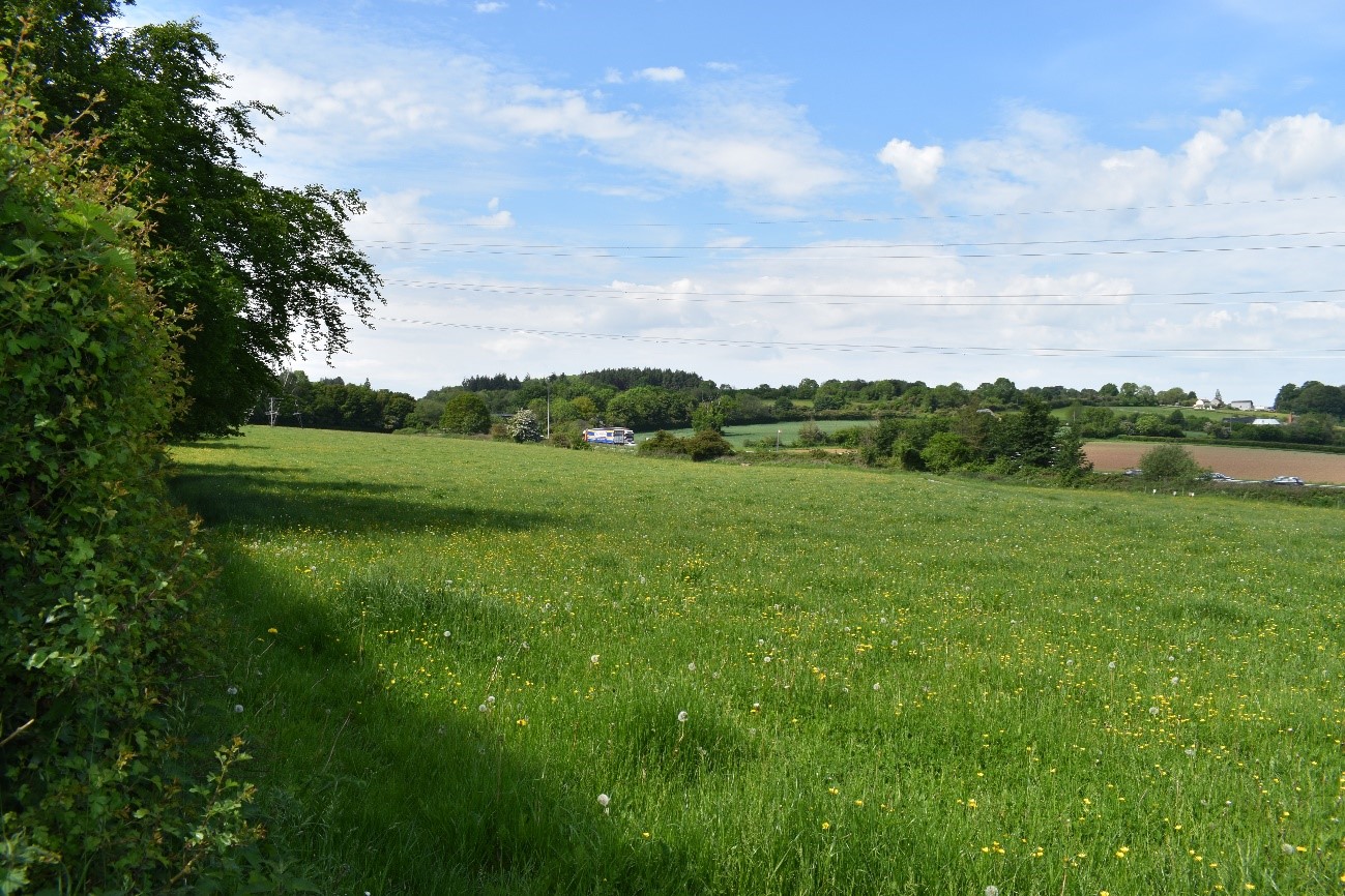
Mature woodland covers the rollling hillsides and helps to integrate the M5 motorway into the landscape.
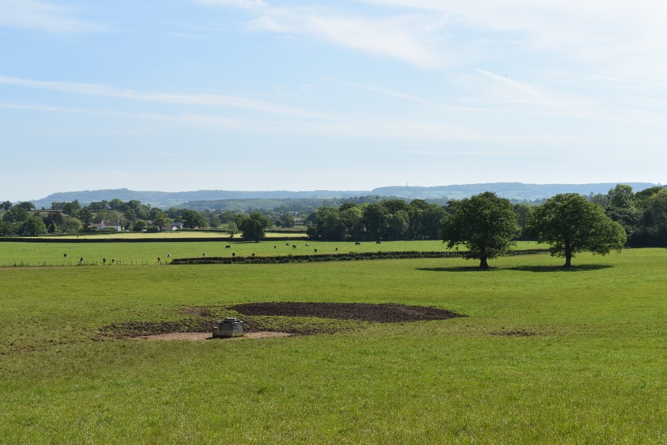
Mature in-field trees within pasture fields, and mature woodland near Falfield.
Landscape sensitivities
Landform (including scale and pattern)
- A gently undulating landform within a low-lying bowl-shaped vale, rising to a scarp edge to the west and the Severn Ridge to the east (both outside the LCT). A smaller steep sided valley cuts through Tortworth Park. These diverse landform features could be masked by large-scale woodland expansion.
- Wicks Hill and Abbotts-side Hill form part of the Severn Ridge which runs diagonally through the area, and are locally-prominent features within the landscape. Woodland expansion could enhance the wooded framework across these landforms and reinforce the landscape structure.
Field and landcover pattern
- The diverse landcover pattern of farmland, open grassland, large deciduous woodlands, ornamental parklands with specimen trees are sensitive to new woodland planting which could result in the loss of the characteristic landscape pattern.
- The medium to large-scale fields in the west of the LCT would be less sensitive to new woodland planting that could enhance habitat connectivity across the farmed landscape. Small-scale, irregular pasture fields to the east of the A38 would be more sensitive to new planting which could mast the distinctive field pattern.
- Areas of ancient woodland would be sensitive to woodland expansion if quantity and species of tree was not considered. However, carefully sited new woodland could enhance connectivity or act as a buffer to protect against changing weather patterns.
Historic landscape character
- The designed parkland landscapes of Tortworth Court and Eastwood Park are locally distinctive historic landscapes combining farmland, woodland, streams and ponds, grassland and specimen trees, and ornamental lakes, the balance of which would be sensitive to woodland expansion that could mask the historic integrity and character of the landscape.
- The presence of Prehistoric assets including two Iron Age hillforts and the site of Roman villa (Scheduled Monuments) indicates higher sensitivity to new woodland planting, which would need to consider potential for physical harm to these heritage assets and their landscape setting.
Visual character (including skylines)
- Uninterrupted views across the vale towards the Severn Ridge and Cotswold Scarp are an important characteristic of the landscape which would be sensitive to new woodland planting that could enclose these open view
- Visual character is more enclosed from lower elevations, such as west of the M5 in Eastwood Park where the linear woodlands and a dense hedgerow structure screens and encloses views, making this landscape less sensitive to further woodland planting.
- The strong landscape framework of woodland, parkland and hedgerows helps to integrate settlement, road infrastructure and other features into the landscape and creates visual diversity. New woodland planting, if not sensitivity located, could detract from the varied and intricate visual character of this landscape.
- Skylines are undeveloped and often appear wooded or partially vegetated within longer distance views. This would result in lower sensitivity to new woodland planting, which would be in keeping with the existing wooded character of the landscape.
Perceptual and scenic qualities
- A scenic, rural landscape with a strong sense of time depth and distinctive character resulting from the historic field patterns, and its strong parkland character. Designed planting, including veteran and specimen trees, are an important element of the landscape which would be sensitive to new woodland planting that could conceal these historic features.
- The presence of modern development such as the M5 corridor, large scale prison complexes and modern agricultural sheds disrupt the tranquillity and rural character of this LCT. New woodland planting could help to integrate these features into the landscape
Assessment of landscape sensitivity to tree and woodland planting
Summary
The LCT would have low sensitivity to small and small-medium sized woodland planting as it would be consistent with existing pattern of woodland coverage. Smaller-scale woodland planting could reinforce the existing field patterns and increase the number of hedgerow trees, woodland blocks and copses, and add depth and variation, particularly in lower lying areas of the vale, . This scale of new woodland planting would be valuable in providing connectivity between, and buffering of, existing ancient woodlands. As outlined in The Forest of Avon’s Tree and Woodland Strategy, strategic planting of new small and small-to-medium-sized woodlands could bridge the “Tortworth Gap”, connecting the woodlands in Tortworth Park with outlying woodlands (including northwards towards Michael Wood and southwards towards Tytherington). Similarly, these new woodlands could also bridge the “M5 Gap,” linking woodlands at Cromhall across the M5 to Milbury Heath woodlands and potentially extending south of Thornbury. New small woodlands could link and enhance Ancient and Semi-Natural Woodlands located between the A38 and Rockhampton with those in LCA 18 (Severn Ridges).
This LCT has several existing areas of medium-sized woodland, and new planting could provide opportunities to enhance woodland connectivity along existing landform features. Medium-sized woodland could also be used to screen and buffer existing modern development, such as the M5 corridor, as well as increase connectivity of the linear woodland pattern along the railway line.
There is currently one large mixed woodland within this LCT associated with Tortworth Park, stretching across Wick’s Hill and Abbotts-side Hill. There may be some opportunities for further woodland planting of this size, however any new planting would need to be carefully sited so as not to mask other landscape characteristics, including the mosaic of existing historic parkland, semi-natural grassland habitats, and expansive views afforded from more open areas. Due to these limitations, opportunities for new large scale woodland planting are limited in this LCT.
There are currently no commercial conifer plantations within this LCT. The introduction of this type and size of woodland would be inappropriate in this landscape and would detract from the existing landscape character.
Any variations in landscape sensitivity
There is only one LCA within this LCT.
| Criteria | Small size native woodlands and trees outside woodlands (≤5ha) | Small-medium size native woodlands (>5 to 15ha) | Medium size native or mixed woodlands (>15 to 30ha) | Large size native or mixed woodlands (>30ha) | Medium-large size conifer plantation (>15ha) |
| Landform (including scale and pattern) | Low | Low | Moderate | High | High |
| Field and landcover pattern | Low | Low-Moderate | Moderate | High | High |
| Historic landscape character | Low | Low-Moderate | Moderate-High | Moderate-High | High |
| Visual character (including skylines) | Low-Moderate | Moderate | Moderate-High | High | High |
| Perceptual and scenic qualities | Low | Low-Moderate | Moderate | Moderate-High | Moderate-High |
| Overall score | Low | Low-Moderate | Moderate | High | High |
Tree and Woodland planting guidance
- Design new woodland to enhance and complement the landform pattern and align along the existing contours of the landscape, including elevated land associated with the Severn Ridge.
- Maintain the small-scale, irregular field pattern in the east of the LCT, restoring lost and degraded lengths of hedgerows and planting new hedgerow trees to help to strengthen biodiversity value and habitat connectivity across the landscape.
- Avoid siting woodland across multiple fields which would mask the small-scale historic field patterns and diminish the historic landscape character.
- Seek opportunities to enhance wildlife habitat corridors across the character area, including species rich grassland and woodland habitats, to enhance biodiversity value and contribute to local nature recovery networks.
- Seek opportunities to increase woodland habitat as part of quarry restoration works (e.g. at Cromhall Quarry) to enhance habitat connectivity and contribute to nature recovery networks across the landscape.
- Protect ancient woodland with appropriate buffers and encourage natural regeneration of appropriate sites; for example, the woodland areas of Tortworth Copse.
- Maintain the distinctive parkland landscapes at Eastwood Park and Tortworth Park through active woodland management (including specimen tree planting, replacement or new woodland and arboretum planting, and complementary new hedgerow tree planting), as well as maintaining appropriate grazing levels.
- Enhance and extend wood pasture and parkland habitat associated with the historic parkland estates. Seek opportunities to enhance connectivity with nearby woodland habitats to enhance connectivity across the landscape, for example the complex of ancient and semi-natural woodlands between the A38 and Rockhampton (in adjacent LCTs 7: Undulating Ridge and LCT 8: Levels).
- Ensure new woodland planting does not detract from the integrity and setting of historic buildings and assets including Prehistoric monuments and features associated with the historic parkland estates.
- Ensure new woodland does not enclose the uninterrupted views across the vale towards the Severn Ridge and Cotswold Scarp, which are an important characteristic of this landscape.
- Utilise new tree planting along the M5 motorway corridor, along the southern margin of Eastwood Park Prison, and around new developments, to reduce the visual impact of built development in the landscape.
- Refer to LCA-specific guidance as set out in the Forest of Avon Plan.
- Any new planting should follow principles of good design, as set out in the UK Forestry Standard.