Forest of Avon

6.2 LCT 2: Shallow Ridge
The map below shows the location of LCAs within LCT 2: Shallow Ridge. - View map full screen
For help on how to use this map click here.
Landscape Character Type description
The Shallow Ridge LCT is a plateaux and vale landscape, defined by a low, undulating ridge that runs north to south across the east of South Gloucestershire. The LCT is located to the west of the Cotswold Scarp, which forms a prominent backdrop in views. This is a rural area of mixed farmland, with fields contained within a strong hedgerow framework. Within South Gloucestershire, LCT 2 comprises LCA 5: Wickwar Ridge & Vale and LCA 6: Pucklechurch Ridge & Boyd Valley, as described in the South Gloucestershire LCA SPD (draft for adoption 2024), and shown on the mapping provided.
The eastern edge of the LCT falls within the Cotswolds National Landscape (CNL). A large portion of the LCT falls within South Gloucestershire Strategic Green Infrastructure Corridor D (Westerleigh Vale/Oldland Ridge/East Fringe), and some small areas within Corridor E (Cotswold Scarp and Ashwicke Ridges) and Corridor B (Western Scarp/Severn Ridges). The LCT is also covered by a large portion of South Gloucestershire Strategic Blue-Green Infrastructure Corridor H (Boyd Valley) and a small part of Corridor C (River Frome Corridor) and Corridor I (Little Avon River Corridor). Corridors D, E, H and C form part of a wider strategic GI network that has been identified to protect designated landscape, heritage and ecological sites and features, well as connecting green and blue infrastructure for the benefit of both people and nature. Further detail is provided in the South Gloucestershire GI Corridor Mapping report (draft for adoption 2024).
Existing tree and woodland coverage
Woodland cover comprises 7.7% of the total landcover across the Shallow Ridge LCT, being higher to the north in LCA 5 (Wickwar Ridge and Vale). Ancient woodland accounts for 3.8% of landcover, with an extensive area at Lower Woods Complex (SSSI and Local Wildlife Site), which includes traditionally coppiced woodlands surrounded by ancient woodbanks. Elsewhere, woodland occurs in small blocks and copses scattered throughout the area. Individual mature trees, hedgerow trees, ornamental trees on golf courses, and small areas of traditional orchards around farms further contribute to the wooded character of the landscape.
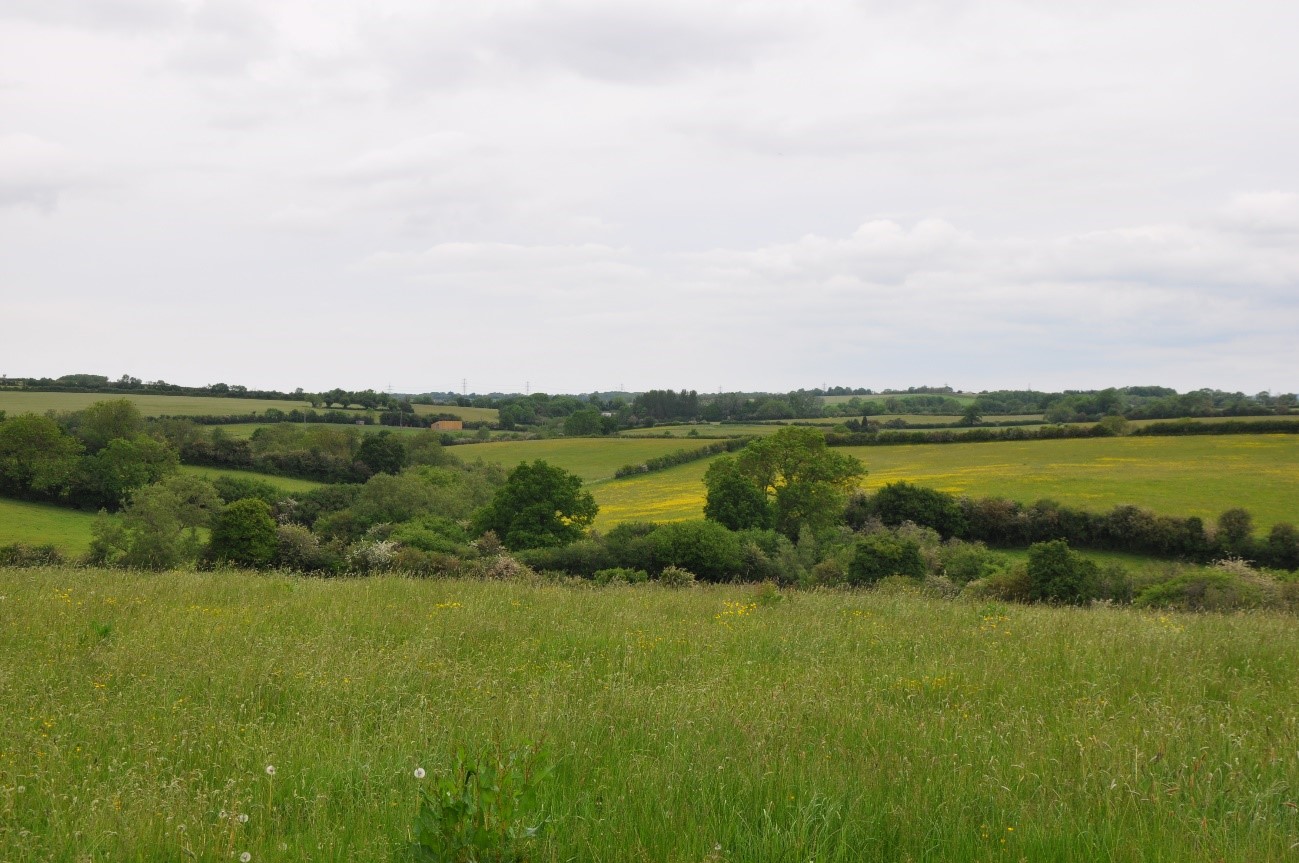
Woodland is typically concentrated in stream valleys, such as the Feltham Brook (LCA 5).
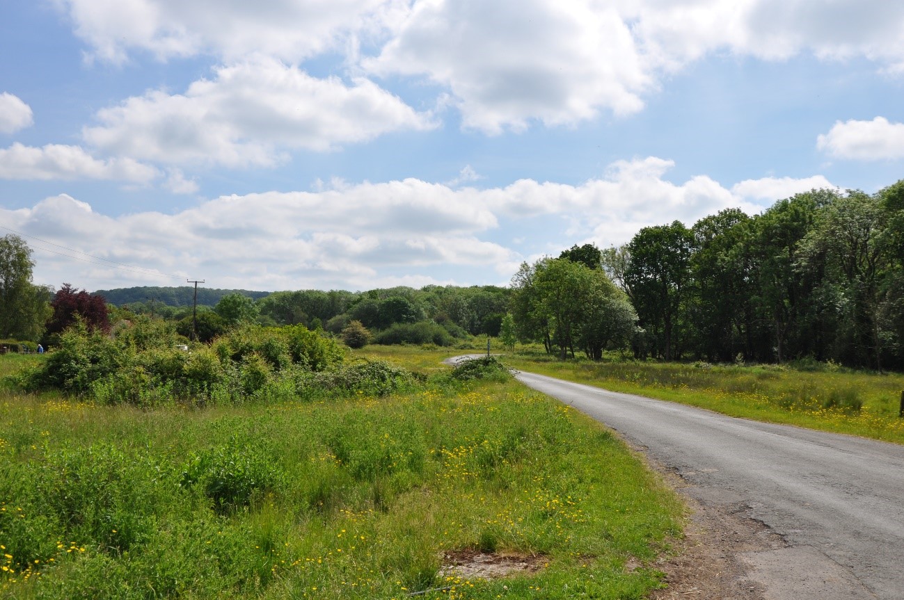
Lower Woods on Hawkesbury Common (LCA 5).
Landscape sensitivities
Landform (including scale and pattern)
- The large-scale, undulating plateaux and vale landscape (ranging between 80m AOD – 130m AOD) indicates lower sensitivity to new small and small-medium size woodland which could accentuate existing contours of the landscape.
- The small-scale, sinuous valleys of the Little Avon and Boyd rivers would be sensitive to new large-scale woodland planting which could mask their more incised landform.
Field and landcover pattern
- The pattern of irregular small to medium size fields in the north (LCA 5) would be sensitive to large-scale woodland planting that would mask the existing landscape structure. However, small-scale tree planting and small woodland blocks could reinforce the existing field pattern and enhance habitat connectivity.
- The larger, regular fields, particularly on the plateau (LCA 6) would be less sensitive to medium-large scale woodland planting which could enhance the hedgerow framework and add texture and visual diversity.
- Existing semi-natural grassland habitats characterise the elevated ridges and unenclosed commons (Sodbury, Inglestone and Hawkesbury Commons), some of which are designated as SSSI and Local Wildlife Sites. These habitats would be sensitive to woodland expansion, which could result in the loss of landscape and habitat diversity.
- Ancient woodland and SSSI-designated woodlands, including Lower Woods (LCA 5), the largest ancient woodland in the south-west, are vulnerable to insensitive woodland expansion that could result in loss of landscape and habitat diversity. However, carefully sited new woodland could enhance connectivity or act as a buffer to protect against changing weather patterns.
Historic landscape character
- The extensive historic field patterns, particularly south of the M4, includes ancient unenclosed commons, and medieval/post-medieval enclosures which would be sensitive to woodland expansion that could mask the remaining historic field patterns and diminish the historic character of the landscape.
- The presence of historic assets of national significance including a prehistoric bowl barrow, an Iron Age settlement, three Roman Villas and a medieval stone bridge at Wickwar (all Scheduled Monuments), indicate higher sensitivity to woodland planting that could have the potential for physical harm to these heritage assets, or impact on their setting.
- Many of the historic villages are designated as Conservation Areas (Chipping Sodbury, Wickwar, Pucklechurch, Dyrham, Doynton and Siston Court). Key views towards and from these settlements would be sensitive to woodland expansion that could impact their setting and significance in the wider landscape.
Visual character (including skylines)
- The LCT forms part of the rural setting to the Cotswolds National Landscape to the east and is directly overlooked by the Cotswold Scarp . The landscape would be sensitive to large-scale woodland planting that could enclose these key visual relationships.
- The Churchend Ridge, Wickwar Ridge (LCA 5) and Pucklechurch Ridge (LCA 6) are noted as Visually Important Hillsides (VIH) and afford views (identified as Strategic Viewpoints) across the LCT and towards the Cotswolds National Landscape. Additional Strategic Viewpoints (SVPs) situated along PRoWs and commons also provide views across the landscape and beyond. The landscape is sensitive to planting, which could interfere with these key visual relationships.
- Historic church towers form local landmarks on the skyline. New woodland planting should be carefully designed and sited to avoid screening views of these features.
- Skyline features including powerlines, wind turbines, elevated sections of M5 motorway, and the settlement edges of Wickwar and Charfield are visually intrusive. New woodland planting could help to integrate these features into the landscape.
Perceptual and scenic qualities
- A scenic, rural landscape with a pleasing combination of features including ridges, broad river valleys, mixed farmland, unenclosed commons, intact hedgerows with mature trees, and historic villages, particularly in the north of the LCT (LCA 5).
- The eastern edge of the LCT is located within the Cotswolds National Landscape. Special qualities that are particularly sensitive to woodland expansion include scenic views to and from the National Landscape, flower-rich grasslands, and the tranquil, rural character.
- The rural character and sense of tranquillity are disrupted by the presence of traffic on major roads, railway lines, golf courses, solar farms, mineral workings, and quarries, notably in LCA 6 (Pucklechurch Ridge and Boyd Valley) New woodland planting could help to integrate these features into the landscape.
Assessment of landscape sensitivity to tree and woodland planting
Summary
Small and small-medium-sized woodland is typical of this landscape and could generally be accommodated across the LCT. This scale of woodland planting could increase habitat connectivity and reinforce the existing patterns of tree cover along watercourses and field boundaries without adversely impacting the landscape character. New small-medium size woodland could be used to link existing small native woodlands in the Boyd Valley corridor between Wick and Doynton (LCA 6), as set out in the Forest of Avon Plan.
Medium size woodlands are infrequent in this LCT. New planting of this size could provide opportunities to enhance woodland connectivity across the LCT and with adjacent landscapes in the surrounding ridges and valleys. However, the overlay of medium-sized woodland planting could risk masking the existing areas of small-medium scale and irregular field pattern, some of which are medieval in origin. Areas of species-rich grassland, including calcareous grassland, would be sensitive to new woodland of this size if inappropriately located. New medium-size native woodland planting (or smaller-scale woodlands) could enhance connectivity between Lower Woods (LCA 5) and the adjacent Cotswold Scarp (LCA 4) as set out in the Forest of Avon Plan Tree and Woodland Strategy. Similarly, establishing woodlands of such sizes within LCA 6 could extend woodland at Overscourt Wood (LCA 12), connecting to existing woodland at Golden Valley Nature Reserve in the south of LCA 6, forming a continuous woodland corridor. Medium-sized woodlands could also be used to screen settlement edges around Pucklechurch and Wick. New medium-scale woodland planting should be sited and designed as to avoid masking key views from SVPs and VIH.
Large woodland is not typical of this LCT, the only woodland of this size being at Lower Woods in LCA 5: Wickwar Ridge and Vale. There may be potential to extend this area further to buffer ancient woodland sites. However, the introduction of new ‘stand-alone’ woodlands of this size would be largely unsuitable across the LCT as it could mask the remaining smaller scale historic field patterns, enclose the open character of the LCT screening long views from the elevated areas across the LCT and towards the Cotswolds National Landscape (particularly key views from SVPs and VIH) and reduce the extent of semi-natural grassland habitats.
There are currently no commercial conifer plantations within this LCT. The introduction of this type and size of woodland would be incongruous with the existing landscape pattern and would detract from the distinctive characteristics of the landscape, including small-medium scale field pattern, unenclosed commons, the mosaic of grassland and deciduous woodland habitats, and the scenic qualities of the landscape identified through its designation as part of the Cotswolds National Landscape.
Any variations in landscape sensitivity
There are no variations in woodland sensitivity within this LCT.
Table A.1: Assessment of landscape sensitivity to tree and woodland planting: assessment scores
| Criteria | Small size native woodlands and trees outside woodlands (≤5ha) | Small-medium size native woodlands (>5 to 15ha) | Medium size native or mixed woodlands (>15 to 30ha) | Large size native or mixed woodlands (>30ha) | Medium-large size conifer plantation (>15ha) |
| Landform (including scale and pattern) | Low | Low | Low-Moderate | Moderate-High | High |
| Field and landcover pattern | Low | Low | Low-Moderate | Moderate-High | High |
| Historic landscape character | Low | Low | Low-Moderate | Moderate-High | High |
| Visual character (including skylines) | Low | Low-Moderate | Low-Moderate | Moderate | High |
| Perceptual and scenic qualities | Low | Low-Moderate | Low-Moderate | Moderate-High | High |
| Overall score | Low | Low | Low-Moderate | Moderate-High | High |
Tree and Woodland planting guidance
- Enhance riparian woodland habitats along the River Frome in line with the aims of the River Frome Reconnected project, as well as along the River Boyd and Little Avon River, and other tributaries using native species such as willow.
- Avoid siting woodland across multiple fields which would mask the small-scale historic field patterns. Seek opportunities to integrate new hedgerow trees and small copses within the historic field framework.
- Create woodland corridors between Lower Woods and the Cotswold Scarp habitat mosaic in line with the aims of the Forest of Avon Plan, ensuring important views towards landscape and historic features are not masked or enclosed.
- Enhance connectivity between semi-natural woodland and grassland habitats, including lowland meadow and good quality semi-improved grassland on and between the commons, whilst maintaining their open character and biodiversity value.
- Promote new small-medium-scale farm woodlands, where this supports farm diversification and fits with the existing character of wooded farmland.
- Protect and enhance the network of hedgerows, trees, and woodlands to ensure the conservation of these key features for the long term, as well as conserving and enhancing habitat value and connectivity, in line with the aims of the Common Connections project.
- Protect and buffer areas of ancient woodland, including at Lower Woods SSSI, using appropriate fringing and encouraging natural regeneration where appropriate.
- Preserve and enhance the landscape setting of Conservation Areas, together with key views to and from key features, including listed buildings. Ensure new woodland planting does not detract from their landscape setting, or enclose key views to and from the settlements.
- Seek opportunities to soften settlement edges, including prominent development on upper slopes of the Boyd Valley on the edge of Wick, and new development on settlement edge of Pucklechurch, using species that are in keeping with the local landscape character.
- Retain the open character of the landscape and ensure that woodland expansion does not enclose key views within, across and out from the LCA, including towards the Cotswold Scarp. Encourage and focus larger scale woodland planting on lower-lying land.
- New woodland planting in areas of the LCT that fall within the Cotswold National Landscape or its setting should be designed to complement and reflect the key characteristics of the area, reflecting guidance set out in the Cotswolds AONB Landscape Strategy Area 19: Unwooded Vale and taking into account the special qualities of the National Landscape.
- Refer to LCA-specific guidance as set out in the Forest of Avon Plan.
- Any new planting should follow principles of good design, as set out in the UK Forestry Standard.