Forest of Avon

6.6 LCT 6: Broad Valleys
The map below shows the location of LCAs within LCT 6: Broad Valleys. - View map full screen
For help on how to use this map click here.
Landscape Character Type description
The LCT comprises a series of broad valleys in the west of the district, located to the north and east of Bristol. Urban areas to the north and west of the LCT have limited pockets of open space, but further east there is a mix of urban fringe land uses and some remaining farmland.
Within South Gloucestershire, LCT 6 comprises LCA 12: Westerleigh Vale & Oldland Ridge, LCA 13: Frome Valley, LCA 14: Kingswood, and LCA 15: Patchway, Filton and the Stokes, as described in the South Gloucestershire LCA SPD (draft for adoption 2024), and shown on the mapping provided.
Note that this assessment covers LCA 12: Westerleigh Vale and Oldland Ridge and LCA 13: Frome Valley. LCA 14: Kingswood and LCA 15: Patchway, Filton and the Stokes are not included in this assessment as they are predominantly urban and have limited opportunity for woodland planting at scale. However, smaller scale planting within these urban areas is encouraged and can still make a contribution to the Council’s tree planting targets.
The woodland cover statistics below account for the whole LCT, inclusive of LCA 12, LCA 13, LCA 14 and LCA 15.
South Gloucestershire Strategic Green Infrastructure Corridor D (Westerleigh Vale/Oldland Ridge/East Fringe) covers a large proportion of LCA 12, and Corridor C (River Frome Corridor) covers the central river corridors running through LCA 13. Corridors D and C form part of a wider strategic GI network that has been identified to protect designated landscape, heritage and ecological sites and features, well as connecting green and blue infrastructure for the benefit of both people and nature. Further detail is provided in the South Gloucestershire GI Corridor Mapping report (draft for adoption 2024).
Existing tree and woodland coverage
Woodland cover across the Broad Valleys LCT accounts for 4.5% of total landcover, typically occurring along watercourses, road and railway corridors, with small fragments of ancient woodland within parkland and around areas of common land. The interlocking nature of these features has resulted in some areas of good connectivity relative to the extent of woodland coverage in LCA 13. More consistent woodland coverage can be found in the lower half of LCA 13 and the centre of LCA 12 associated with older settlement and commons. The southern part of LCA 12 includes the west side of the Oldland Ridge and has limited woodland cover. The network of hedgerow and mature hedgerow trees along field boundaries strengthens the woodland framework in this LCT.
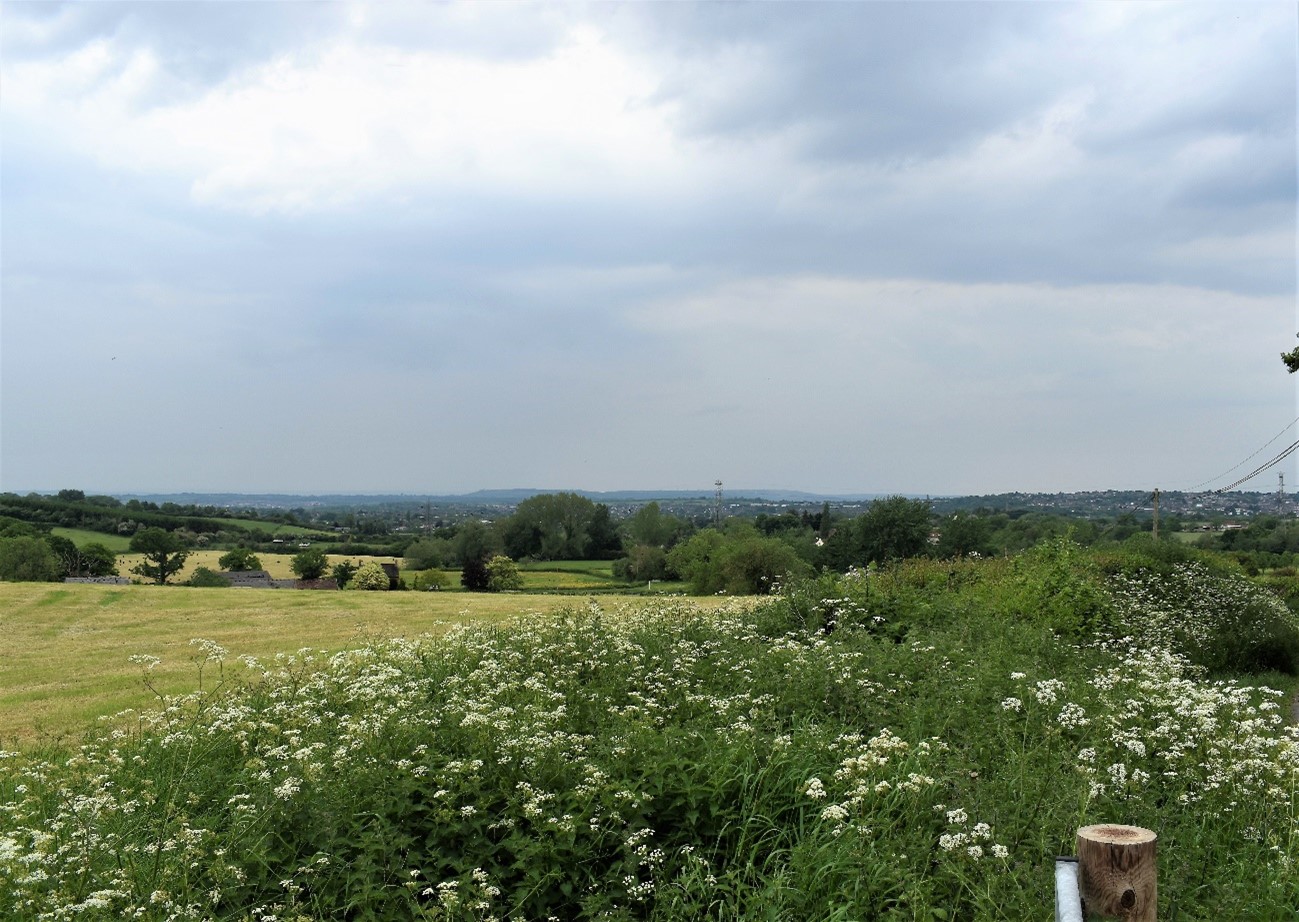
Undulating fields enclosed by hedgerows with hedgerow trees along the Oldland Ridge (LCA 12).
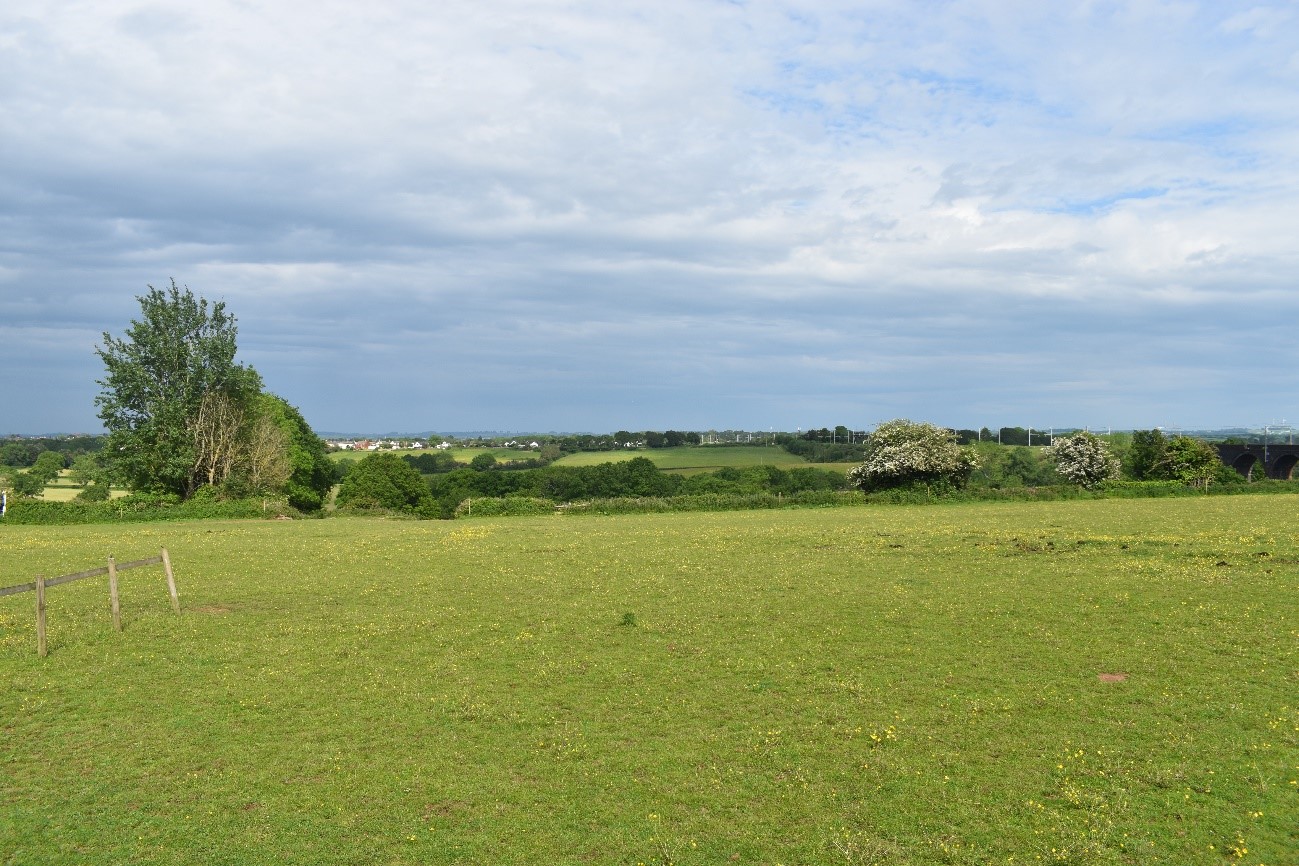
View across the wooded Frome Valley (LCA 13). Hedgerow trees contribute futher to the canopy cover in the surrounding agricultural landscape.
Landscape sensitivities
Landform (including scale and pattern)
- The shallow valleys of the River Frome, Bradley Brook and Folly Brook has a lower sensitivity to new woodland planting which could complement the gentle undulations of the landform.
- The Pucklechurch Ridge and Oldland Ridge in the east (identified as Visually Important Hillsides) are sensitive to large-scale woodland expansion due to their prominent landform. However, new small and medium-scale woodland planting could emphasise the existing contours of the landscape, following the natural vegetation pattern where it exists.
Field and landcover pattern
- The rural landscape consists of a regular pattern of fields interspersed with horse paddocks, a golf course and common land including at Siston, Bridgeyate, and Webbs Heath and Rodway Commons.
- Areas of suburban land use including modern residential development, large-scale industrial sheds, plant nurseries and storage compounds would be less sensitive to new woodland planting which could strengthen the existing rural landscape framework and better integrate these features.
- Existing semi-natural grassland habitats, including lowland dry acid grassland and good quality semi improved grassland (many of which are Local Wildlife Sites) are sensitive to woodland creation which could result in the loss of landscape and habitat diversity, particularly in areas where habitats are already fragmented.
Historic landscape character
- The northern part of Stoke Park (a Registered Park and Garden) falls within LCA 13 and contains a network of woodland (including ancient woodland) that extends beyond the park over Sims Hill. Sensitively sited new woodland could strengthen and enhance this historic wooded character further into the LCA.
- Visible industrial relics associated with the coal industry including railway viaducts and disused collieries at Ram Hill and Brandy Bottom (Scheduled Monuments) reinforce the industrial heritage of the landscape and would be sensitive to being masked by new woodland planting.
- Bury Hill Fort (Scheduled Monument) in LCA 13 is another distinctive historic feature within an open landscape setting that would be sensitive to new woodland planting encroaching into the historic site.
- Conservation Areas at Frenchay, Hambrook, and Siston would be sensitive to new planting that could mask their historic integrity and setting if inappropriately sited.
Visual character (including skylines)
- The rural character of the Borad Valleys LCT is segmented by motorway and railway infrastructure. This results in lower sensitivity to new woodland which would help screen traffic movement and buffer noise pollution, enhancing rural character, particularly adjacent to historic town centres, Stoke Park, and public footpaths.
- The Oldland and Pucklechurch Ridges form a rural backdrop to views from nearby settlements, including Siston and Pucklechurch Conservation Areas and would be sensitive to new woodland planting that could enclose their open skylines.
Perceptual and scenic qualities
- Pockets of rural character and localised tranquillity remain across the LCT. However, the rural character is eroded by proximity to the urban conurbation of Bristol, mixed ‘urban fringe’ land uses on the urban edge, and transport corridors. These qualities result in a lower sensitivity to woodland planting which could strengthen landscape character within the LCT and screen and buffer urban and suburban land uses from the wider landscape to the west.
Assessment of landscape sensitivity to tree and woodland planting
Summary
Small and small-medium sized woodland is typical of this landscape and further woodland planting of this size could be accommodated. New planting could enhance riparian habitats along the River Frome, Siston Brook, Folly Brook, and Warmley Brook. Woodlands of this size could also enhance the landscape character of this LCT by screening modern development and transport corridors. New small woodlands could also enhance the agricultural landscape by integrating small copses, hedgerow trees into these areas. The Forest of Avon Plan outlines opportunities for strategic new small and small-medium sized woodland to link Kendleshire Golf Course (LCA 12) through the “Westerleigh Gap†to existing woodland along the Pucklechurch Ridge and Boyd Valley (LCA 6). Similarly, woodlands of this size could contribute to the creation of new woodland corridors between Overscourt Wood, Warmley Forest Park, and the Shortwood Landfill Site (all within LCA 12).
There are currently no medium size woodlands within the LCT, however new woodland of this size could strengthen existing fragmented woodland corridors, such as along the River Frome in LCA 13. The dense woodland corridor along the River Frome south of the LCA boundary sets a precedent for a more densely wooded character that could be continued into LCA 13, and would provide valuable habitat. Similarly, linear woodland of this size could be used to screen transport corridors, such as the M4 corridor in LCA 13.
There are currently no large sized woodlands within this LCT, however, the urban influence of Bristol to the west, sub-urban land uses on the western edge of LCA 12, and the presence of major road corridors, results in lower sensitivity to woodland creation which could help to mask these detractive features and enhance landscape character overall. Whilst any intervention of this scale would need to consider key landscape sensitivities, such as views to and from Pucklechurch and the Oldland Ridge, there could be potential for large-scale woodland creation between the urban edge and landscapes of more rural character. This could absorb and integrate detracting landscape features and reduce the visibility of Bristol as an urban backdrop.
There are currently no commercial conifer plantations within this LCT. This type and size of woodland is unlikely to be accommodated in the Broad Valleys LCT due to the limited land area available, as well as the sensitivities listed above.
Any variations in landscape sensitivity
There is no variation in landscape sensitivity in this LCT.
| Criteria | Small size native woodlands and trees outside woodlands (≤5ha) | Small-medium size native woodlands (>5 to 15ha) | Medium size native or mixed woodlands (>15 to 30ha) | Large size native or mixed woodlands (>30ha) | Medium-large size conifer plantation (>15ha) |
| Landform (including scale and pattern) | Low | Low | Moderate | Moderate-High | Moderate-High |
| Field and landcover pattern | Low | Low | Low-Moderate | Moderate-High | Moderate-High |
| Historic landscape character | Low-Moderate | Low-Moderate | Moderate | Moderate | Moderate |
| Visual character (including skylines) | Low | Low | Moderate | Moderate-High | Moderate-High |
| Perceptual and scenic qualities | Low-Moderate | Low-Moderate | Moderate | Moderate | Moderate |
| Overall score | Low | Low | Low-Moderate | Moderate-High | Moderate-High |
Tree and Woodland planting guidance
- Design new woodland to align with the gently sloping contours of the broad river valleys.
- Actively manage and strengthen hedgerows, trees and woodlands to ensure the conservation of these key features for the long term as well as conserving and enhancing habitat value and connectivity, in line with the aims of the Common Connections project.
- Enhance riparian planting along the River Frome in line with the aims of the River Frome Reconnected project as well as along the Bradley Brook, using native species such as willow.
- Ensure new woodland planting does not damage important semi-natural grassland habitats, including on Siston, Bridgeyate, and Webbs Heath and Rodway Commons. Seek opportunities to create wildlife corridors between habitat using small scale woodland planting, to enhance habitat connectivity.
- Ensure that new woodland planting does not mask the character, significance or setting of conservation areas including Siston Conservation Area and features associated with Siston Court, including the formal grounds and parkland landscape.
- Secure the retention, restoration, and management of hedgerows to reinforce both local character and habitat value and connectivity. Active management and strengthening of the hedgerow framework, trees, and woodlands, including replacement and new planting, to help to ensure the conservation of these key features for the long term as well as diversity and connectivity of habitat.
- Ensure that the open skylines Oldland Ridge and Pucklechurch Ridge, (including views towards and from the Cotswold Scarp) are not enclosed by new woodland planting.
- Reinforce existing urban edge woodland to enhance their contribution to the setting of settlements and help to assimilate new development into the landscape. Ensure new housing developments deliver high quality, multi-benefit woodland seeking to connect new woodland planting with existing woodlands.
- Manage and enhance parkland trees and woodland within Stoke Park to optimise their heritage, landscape and biodiversity value, and protect ancient woodland with appropriate buffers.
- Promote new small-medium-scale farm woodlands, where this supports farm diversification and fits with the existing farmland landscape.
- Establish groups of trees and woodlands to further integrate diverse land uses in the wider landscape, with a particular focus on road and rail corridors, including along the M4, M32, and A4174.
- Refer to LCA-specific guidance as set out in the Forest of Avon Plan.
- Any new planting should follow principles of good design, as set out in the UK Forestry Standard.